The route that became known as Redington Pass has been in existence for hundreds of years. It was originally used by natives and eventually improved to facilitate a military supply route used to commute between the San Pedro River Valley and the booming metropolis of Tucson, Arizona. The overland route cut roughly 70-100 miles off the alternate routes which were to go either north through Oracle and back south, or south through Benson and back north in order to reach Tucson. The route was later used by the small ranching community of Redington, Arizona.
Redington Pass is now a gateway to hiking and Off-Road trails in the Catalina and Rincon Mountains, east of Tucson, Arizona and into the San Pedro River Valley as well. This route is the perfect light day trip to escape the city or just a short drive up a hill to a great view of the Tucson area. During good winters this route can be a nice place to encounter some snow at elevation that hasn't quite reached the desert floor.
Trail Difficulty and Assessment
Recommended Vehicle:
2WD Vehicle with High Clearance
Concerns:
Summary:
This road can be easily traversed in a high clearance two wheel drive. Redington road is maintained occasionally by Pima County Department of Transportation by grading, however, this activity is generally constrained to the Western slope up to the Alambre staging area (where the bathroom is located).
Use caution on the switchbacks of the Western Slope as monsoon rain and winter storms tend to generate washouts that will rattle your frame or tear out your oil pan if you aren't paying attention.
Community Consensus
0 votes
3 votes
0 votes
Easier
Spot On
Harder
The weighted average of your fellow members agreement of our trail
rating. As trail conditions change this helps us keep the community
aware of changes.
Mandatory
1 -
EASY
The hardest part of the trail that you
cannot bypass - you have to drive it.
Optional
1 -
EASY
The hardest part of the trail that is
purely optional - you can bypass it.
Dirt and/or rocky road. Potential rocks and/or tree stumps less than 5" tall and/or vertical ledges less than 5" tall and/or near vertical ledges or waterfalls less than 6" inches. Good tire placement likely. Can be steep, but with good traction.Read More about our Rating System
Redington Road is a well-maintained dirt road that provides scenic views of both the San Pedro River Valley to the east and the city of Tucson to the west as it crosses Redington Pass between the Catalina and Rincon Mountains. Redington Road is maintained by both Pima County and the United States Forest Service, making for a fairly easy drive in dry conditions. However, this road is not a high priority to keep maintained, and as such can be washed out and rutted in sections requiring a high clearance 2wd vehicle at least.
There are three sections to the road:
The Western Slope: A fairly good climb up from 2,500 - 4,800 feet in just 6 miles. You will encounter several switchbacks with stunning views of the Tucson valley floor, and numerous pullouts. The Upper and Lower Tanque Verde trailheads are here as well as the Information kiosk at mile 5. This is where you will find most traffic from Tucson as hikers, sunbathers, quad riders, etc. all flock to this area when the weather is nice.
The Central Plateau: Here you will find numerous points of interest such as the staging area for Chiva Falls, shooting area #3 (Now open by the USFS), the turnoffs to several side trails and the Alhambra staging area with loading ramps, shaded picnic areas, and a vault toilet - the only one currently in the entire length of Redington Road, the turnoff to Belotta Ranch (Start of the Chimney Rock trail), a secondary access point to Chiva Falls (FR4424), the Arizona Trail crossing at mile 12, along with FR37 to Italian Trap are all found here. Several of the fields and hillsides are part of the cattle lease owned by the Tanque Verde Guest Ranch
The Eastern Slope: This area is far less populated, and contains many nice roadside campsites. The A7 Ranch, (Owned by Pima County for the promotion of Conservation goals), the eastern exit of FR4430, the Chimney rock trail is just past it, through some winding saguaro-strewn hillsides to the exit at the tiny ranching hamlet of Redington.
This area can become quite crowded on weekends and user conflicts can arise. Use caution, particularly on the west slope as trailers for OHV's, Shooters, Hikers, Bikers all use this area to recreate.
This section of the road is paved but offers an excellent place to stop, set your odometer to 0.0 to begin your journey. If you do this here, your odometer will roughly match the mile marker signs as you travel along the road. The trail starting point could be classified at the 3.4 mark where the forest line/dirt road begins, but this is an important point nonetheless.
This is the point where the East Tanque Verde road becomes East Redington road.
There is a house that resembles a Norman Castle to the southeast. Rumor has it that the person who invented the 3M Post-It note lives here.
2. Canyon Del Salto Creek Crossing (Paved) (2.8
mi)
This creek crossing is usually a good indicator of the status of creeks and waterfalls up in the pass. Chiva Falls Trail. The water here virtually guarantees water up in the Tanque Verde Creek and on the falls. Conversely, dry does not mean the waterfalls are dry. The road is still paved here.
I hope you filled up your tank at the gas station on Tanque Verde road?
The ranch to the southwest once housed the Grand Canyon mules in the winter and you could ride them up into Saguaro National Park. Now, this ranch is for sale.
3. Forest Border/Cattle Guard (3.4
mi)
At this point the trail turns to dirt until it ends. There is a cattle guard here and a non-standard forest entry sign.
This small 20 space parking area is a challenge itself just to enter. There is usually a washed out portion at the entrance. This results in a lot of passenger cars just parking alongside the road, making this area very congested at times. Lower Tanque Verde Falls is is a very popular day hike trail.
The Southern Arizona Rescue Association (SARA) has laser cut some signs in this area warning of the hazards ahead on the trail.
5. Information Kiosk (Stay Right) (3.9
mi)
At one time the Forest Service maintained an information board at this location. It has since been run over and only the post stumps remain. However, the Friends of Redington Pass has jointly developed a recreation plan with the Forest Service to develop this site with a restroom, trash receptacles and a new information kiosk complying with their sign standards.
There are plenty of spots here for dispersed camping. But it's such a busy place with people coming and going, trailers dropping OHV's off it would be like camping in a vacant lot in downtown Tucson.
A short distance ahead is a small unmarked foot trail that leads to Tanque Verde Falls, one of the most spectacular views in Redington Pass. This unofficial trail can be found by looking for the small parking spot to the north, and the large boulders marking the vehicle barrier to the south of the road. This view down the Tanque Verde Canyon, and of the falls when they are running is well worth the short walk.
There is a small camping site with a fire ring to the north of the parking spot along Redington Road.
These are the famous Tanque Verde Falls. This upper trail (use of which is discouraged by SARA) descends steeply down into a rocky canyon and continues to the upper edge of the falls. An 80-foot drop has claimed 30 lives during flash floods. In 2017, a spectacular helicopter rescue saved some unsuspecting hikers who had become trapped.
There is a small amount of camping to the northwest along a small loop road. This point marks the beginning of the portion of the western slope known as "The Switchbacks".
8. Sunset Rock (Stay Left) (4.7
mi)
One of the iconic spots to pull out and take a picture of your rig against the backdrop of the Tucson valley spreading out below. This small rocky outcrop requires four-wheel drive to ascend, but you could park any rig next to it for a photo. In case you were wondering, this is an awesome spot to watch the sunset.
9. Top of Switchbacks (No parking - Continue Straight) (5.4
mi)
From the top of the switchbacks at mile marker 5.3 to mile 6.3 the Forest Service has closed the road to all parking. This is to discourage shooting along this section as there are two closed areas that were once popular areas for this activity. The only somewhat sanctioned shooting area is at mile 6.3.
Before you reach this point, however, there are several pullouts along the road where one could pitch a tent.
10. Shooting Area #3 (Continue Straight) (6.3
mi)
This small open area to the north of the road is where you will usually find 3 - 4 vehicles pulled off and shooting against the hillside going on. Please pack out whatever you bring in. Shooting areas 1 and 2 were closed due to the large accumulation of trash and lead, which was very expensive for the Forest Service to mitigate.
This is a busy area. There is an Arizona State Parks funded staging area to the south and a corral to the north. The Corral is astride FR#4441 (The Bartender Trail) that leads to a bunch of cocktail named cattle tanks. To the south, FR#4417 begins on the way to the Chiva Falls Trail. Camping is not allowed here because of the two active water sources nearby.
12. Chiva Falls Viewpoint (Look South Continue Straight) (8.3
mi)
While you don't absolutely need binoculars here, they sure help pick out the small ribbon of water that marks the end of the Chiva Falls Trail. Look for the rocky outcropping in the foothills of the Rincon Mountains. The only marker here is a small Forest Service area restoration sign. There is no pull-out, you just stop along the barbed wire fence.
13. FR#4436 (Stay Right) (9.1
mi)
4436 takes off from here to the north. This fun trail heads up the Agua Caliente Hill on a very steep climb. Another impromptu shooting area can be found here at the intersection. This road is four-wheel drive only.
14. FR#4435/Cattle Guard- Racetrack Tank Trail (Stay Right) (9.4
mi)
This road FR4435 leads into a great area to explore. Racetrack tank almost always has an acre or two's worth of water in it. Because there is a good backstop, this is also a popular shooting area. If you follow this road to its end, you'll dump out at the Alambre Staging area.
Most folks just set up their camping rigs here near the intersection, but there are scores of great spots back in this area. Just be sure to stay 1/4 mile away from the Racetrack Tank.
15. Alambre Staging Area (Stay Right) (10.1
mi)
Named for the nearby Alambre Tank to the south, this is the only (current) developed recreation area in the pass. There are multiple shade structures, ATV loading ramps, a pit toilet, trash receptacles and picnic tables here. On the north end of the parking lot, FR3335 spills out from its rough and tumble journey from Racetrack Tank.
This is a pretty big intersection - Stay to the right to follow the Redington Road. To the left is the start of the Chimney Rock Trail. A short distance down this road on the right is a campsite. (Campsite #1 on the Chimney Rock Trail)
17. Roadside Camp Site #1 (North Side-Stay Right) (10.7
mi)
A small pullout on the north side of the road, complete with fire ring offers an almost unobstructed 360-degree view of the pass & Rincon Mountain range. There are no shooting signs here as the 50" ATV trail passes just behind this site. The cattleguard warning sign sits on the other side of the road.
Just over the cattle guard, on the left is a short spur road up the hill, which offers yet another unobstructed view campsite. The ATV trail crosses nearby with a gate in the fence. There is a loop at the end so you only get to go out and back. The odometer reading does not calculate the distance out and back to this hilltop.
19. Hilltop Camp Site(Out and Back) #2 (10.85
mi)
This hilltop campsite offers great views of the Rincon Mountains. (Rincon Mountain and Tanque Verde Peak) You get a great view of Spud Rock from here. The road loops around a big juniper tree and camp spots are along the road.
This spot begins the middle trail into Chiva Falls. This is the easier way to get to the falls, avoiding Three Feathers entirely. This road is, however, the end of FR#4417 which starts at the Three Feathers Staging area previously mentioned. The trail requires a four-wheel drive from here. The ATV trail follows this road for a small distance and crosses the Redington Road here on its way by the hilltop campsite.
21. Camp Spot #3 (Stay Left) (11.3
mi)
This small campsite is off the south side of the road and would support a couple of tents and a single trailer.
22. Large Camp spot #4 (Stay Left) (11.8
mi)
This large campsite could support several fifth wheel trailers or 10 tents. There are multiple fire rings and nice oak tree shaded areas.
23. Camp Spot #5 (Stay Left) (12.3
mi)
This small site on a slight rise to the south is situated next to a small wash. This wash leads to the ATV Trail which crosses it about 100 yards ahead. This spot overlooks the road.
24. Camp Spot #6 (Stay Left) (12.4
mi)
Another small pull off area to the south. It is suitable for a couple of tents or a trailer.
Another small campsite to the south of the road suitable for a few tents. This campsite also hugs a wash.
27. FR#4429 (Stay Right) (13.7
mi)
This spur road leads up into the rolling hills and eventually peters out at a stock tank. There is an alternate path to the west that leads over the rolling hills to a loop turn around. This makes this entire road a dead end out and back.
28. Camp Spot #8 (Stay Left) (13.7
mi)
This small clearing on the south side of the road provides nice views of a small canyon below. It has a fire ring but not much else, being entirely exposed to the elements and roadway. Still, not much traffic makes it this far out on Redington Road so you might get to sleep here all night long.
This is the edge of the forest at this cattle guard. Beyond lies either Pima County land (Managed) or Arizona State Trust Land. A permit is not required if you just are traversing the area on Redington Road as that's Pima County jurisdiction, but if you are planning on driving on the side roads, or camping, you will need a Recreational State Land permit.
This is also the working A7 Ranch property as well.
30. FR#4425 (Stay Left-North) (14.7
mi)
This is a large fork that looks well traveled in both directions. Stay to the left to remain on FR371. To the right is FR4425, which has one of the most interesting plastic signposts to look at there. There are a lot of dangers according to this sign.
31. Camp Spot # 9 (Stay Right) (15
mi)
This small clearing off to the north of the road at a fork where the road also forks again and leads down to a small pasture area. There are the remains of a significant water tending operation down here. You could camp up on top at the knob, or down below in the pasture. It looks as if there is still a lot of cattle activity here.
Another small campsite near a dry water tank. If this tank has water in it, you would not be able to camp near it. There are actually two spots, if you stay to the left when you turn, you'll end up on a promontory with a fire ring. If you make a hard left, almost 180 degrees, you will head down to the flat area with the well and empty tanks. There are quite a few mesquites here for shade.
33. Camp Spot #11 (Stay Right) (16.1
mi)
Around a hillside corner is a small cut leading west between two hills that looks like a shooting spot. There is a fire ring there and enough room for a tent or a trailer. It's pretty exposed to the road however.
34. A-7 Ranch Turnoff (Stay Left) (16.7
mi)
This road leads down to the ranch house. Stay on the left of the fork to stay on Redington Road FR371. Stay away from the ranch house, it's marked as "No Trespassing"
35. East End Chimney Rock Trail FR# 4430 (Stay Right) (17.3
mi)
This is the intersection of the eastern end of the Chimney Rock Trail. This is the exit point of FR4430. You can also run the Chimney rock trail from east to west, starting here.
36. Camp Spot #12 Unmarked Road Piety Hill Overlook (Out and Back) (17.8
mi)
This is another short out and back (Less than 0.1 miles) that overlooks Piety Hill. This road has a flat spot with a fire ring that looks out over a small valley.
37. Camp Spot #13 Un-numbered Road East Face Piety Hill (Stay Right) (17.8
mi)
Small fork in the road, Stay right to remain on 371. This road leads along the northeast face of Piety hill and leads to FR#635, down into Beuhman Canyon and eventually exits on the San Pedro road, north of the intersection with Redington Road.
There is a pretty open field area here with a fire ring. However, this camping spot is astride the road on the north side.
38. Two Dead End 4x4 Roads -East & West, Un-numbered (Continue Straight) (18.2
mi)
This is a four-way intersection with two 4x4 roads. One road heads very steeply west (left) and ends in some rolling hills at a cattle tank. There appears to be some mining activity on the hillsides. The other heads east (switchback right). This is a sharp nearly 180-degree turn heading down into a canyon, but on the left, as soon as you make the turn, you will see an ancient pickup truck that rolled down into the bottom. Stripped nearly to the bone, it's still an interesting artifact to stop and look at.
This road continues on for some time over the hills but also dead ends.
39. Red Tank Trail Entrance (Stay Right) 18.8 (18.8
mi)
This road is the trail start of the Red Tank trail. A small (0.8 mi) shortcut down into a canyon, to a large set of 3 cattle tanks, and a substantial corral. There are three spots to camp on this road.
40. Large Trail Intersection Unknown Road# to BarLY Ranch (Stay Left) (19.4
mi)
This major intersection makes following the road slightly confusing here, as bearing right looks like a traveled road. At this point, stay left to follow FR#371. To the Right is a large, well-traveled road that leads off to the BarLY ranch. There is a sportsman's sign in here for Arizona Game and Fish and another one of those elaborate Forest Service danger signposts. This actually branches off three ways from Redington road.
41. No # 4x4 Road Crossing Dead End East/Wash/Tanks/Corral West (Continue Straight) (19.6
mi)
Two nondescript 4x4 roads lead off to the east and west here. The one to the east leads to a metal water tank and beyond, the one to the left leads down to a wash, a couple of cattle tanks and a pretty large corral. This is the exit point for the Red Tank trail. About 0.1 miles down this road before you descend, there's a camping spot on a knoll.
42. Short Road to Water Tank (Stay Left) (21
mi)
This is a short out and back to a water tank out on the ridge. On the topo map, the road shows as looping back to 371 about 0.7 to the west, but, there's no longer a road there, it's completely (6' deep) washed out and grown over so it's nearly impossible to find.
There's a state land sign here.
43. Unknown Rough Hillside Two Track (Stay Right) (21.4
mi)
A rocky two track leads off along the side of a hill. This road does not look often traveled so it's unknown what the condition is further up.
44. 4x4 Road Down to Nice Wash (Stay Right) (22.5
mi)
A short road that leads down to a sandy wash. It looks as if the road continues up the other bank.
45. Unmarked Road to Gate and Beuhman Canyon Beyond (Stay Right) (24.1
mi)
This short quick 180-degree turn to the left leads to a wood post/barbed wire gate then down to Beuhman Canyon beyond. This lush riparian area looks as if it would be a fine place to camp.
46. Town of Redington Shortcut to Cascabel Road (Stay Left) (25.4
mi)
This major intersection of the Redington Road and the Cascabel Road shortcut through the small community of Redington, Arizona. This leads down and across the San Pedro River so it may not always be passable. There is a bridge further up on Cascabel road that you can use if it's blocked by the river.
At one time there was a gate that said: "No Trespassing" that is no longer present. On the other end at the Cascabel/San Pedro road, there is still a "No Trespassing" sign. It's usually not a problem to travel slowly, without raising any dust, through this shortcut, but be warned, you may be challenged by the land owners.
47. Road to Buehman Canyon (Stay Right) (25.5
mi)
The next large wash that you cross, there are a number of OHV tracks heading back to the west up the wash. This is the access to Beuhman Canyon and the exit point from the road that leads along Piety Hill several miles back up Redington road.
This is a deep sand wash crossing that might present a challenge during rainy weather as it drains a major portion of the eastern Santa Catalina mountain foothills.
48. Unknown Two-Track Road 4x4 to West (Stay Right) (26.2
mi)
Another small road leading to the west. This road looks lightly traveled, and heads up a ridge, joining the Beuhman Canyon road.
49. Edgar Canyon Wash (Continue Straight) (26.9
mi)
Another deep sand wash crossing that might present a challenge during rainy weather as it drains a major portion of the eastern Santa Catalina mountain foothills. There is no need to head up Edgar canyon via the wash as there is a parallel road just ahead.
50. Edgar Canyon road (Stay Right) (27.1
mi)
51. End of Redington Road (San Pedro Road) (27.5
mi)
This is the end of Redington Road. This is the intersection with the San Pedro road which leads left to San Manuel and Right to Benson (about 30 miles away). The bridge over the San Pedro River is a short distance to the south (right) if the river is running and you need to cross.
Dispersed
There is a multitude of camping opportunities in the pass. Each of these locations is detailed in the waypoint section but all are un-improved / dispersed style camping spots.
From Tucson, take Tanque Verde road east until it becomes Redington Road. Continue on Redington Road three miles up a set of paved switchbacks until you hit the dirt at a cattle guard. This is the entrance to Redington Pass and the Coronado National Forest. There will be a sign at the border indicating you are crossing into Coronado National Forest.
Alternative Start/Rally point = Circle K at 11271 E Tanque Verde Rd. This is traditionally the staging area for street-legal vehicles and the last chance for gas/snacks/air. A large dirt lot to the east of the gas pumps holds 30 vehicles. Coordinates are: 32.252240, -110.752616
We drive a well equipped Jeep 2020 Gladiator, so this trip was just for the purpose of taking cool pictures of the scenery. A couple of comments are worth mentioning. We came in from the Tucson side and headed (north) east. The beginning of the trail was annoyingly washboarded so we aired down. If you have this capability, sooner is better. On this side of the route there are a lot of blind, tight switchback turns. It was Sunday, so plenty of opportunity for accident if one is not paying attention. This is a great trail for one who is just getting into off road adventuring. Lots of scenery. Lots of camping sites. A few "challenging" sections of road with some rocks and dips. The good news is that over the weekends there are bound to be plenty of people who can help if you get into trouble. For those who seek further challenge, this trail is the gateway to other more difficult trails. Have fun. Be safe.
Ran Redington Pass again today to get to a couple of trails off of it. This was the first time we've run in from Tucson to the city of Redington. That direction has yields some very scenic views of the San Pedro River Valley near the north end. If you have a choice, I recommend that direction of travel for the best views. And, yesterday Redington Pass was very wash boarded near Tucson, but surprisingly smooth near Redington.
Decided to take a trip around the Santa Catalina Mountain using Redington Road as part of the path. It's an easy trail with some interesting sights. The roadway seems to have had some work done since it is not as rough as Jim's recent pictures show.
Short visit today. Road is rougher but still passenger car passable. Hiked the scorpion trail and found some new ruins. New forest entry sign pointing out that this area is "Redington Pass". Nice plug for Friends of Redington pass too.
❗️ GO! – Evacuate❗️
This is a combined message from the Pima County Office of Emergency Management and the Pima County Sheriff’s Department.
As part of the Ready, Set, GO! process, the area below is now in the “GO!” state and is being evacuated. If you are in the area below, EVACUATE NOW. Safely move away from the Catalina Mountains. Do not delay leaving the area.
The evacuation zone is the Redington community bordered by the county lines on the north and east sides. The western and southern boundaries do not follow any specific road. Please refer to the interactive map at http://bit.ly/PCBigHornFire for specific details. If you are in this area, you are in the GO! area.
Redington Road will be closed at the end of the pavement.
The Pima County Sheriff’s Department will be going door to door to make contact with those affected residents who may not have received the message.
This might be the only notice you receive. Emergency services cannot guarantee they will be able to notify everyone if conditions rapidly deteriorate.
Additional messaging will be sent as the situation changes.
Small animal sheltering will be done at Pima Animal Care Center, 4000 North Silverbell Road in Tucson.
Questions from residents in the area should be directed to 351-FIRE (3473)
Bighorn Fire information can be found here: http://www.pima.gov/Bighorn
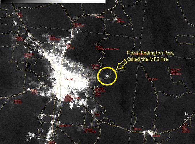
The media reported this morning that the road will be intermittently closed because of a (possibly human-caused), brushfire at Mile Marker 6. This is at approximately Waypoint 10 above. Please use caution in this area and be prepared for a closure at any time.
Kvoa Tucson PCSD responds to MP6 Fire
Redington Pass Road (FR371) has become a popular destination during this COVID 19 lockdown. So much so that it has caused problems for the Search and Rescue folks, blocking access because of too many parked cars.
PCSD Search and Rescue (@PCSD_SAR) tweeted at 0:05 PM on Sat, Apr 18, 2020:
Rescue at Tanque Verde Falls. Unfortunately rescue crews can’t access the scene due to the large amount of vehicles blocking the road. If vehicles can’t pass due to your parking, don’t park there. #sar
(https://twitter.com/PCSD_SAR/status/1251587624642342912?s=03)
There IS a Forest service closure order in effect (That was never seriously enforced before) that can cause you to get a ticket if they want to enforce it anywhere on the western slope, between MM3 and MM 7. SO, move on through, and don't' stop to hike the trails, at least until this situation is over.
There is already a Closure order in effect for shooting and parking/leaving a vehicle in these problem areas. They are ticketing the hell out of people now.
Pursuant to 16 USC 551, etc etc
PROHIBITIONS:
Discharging a firearm ..in the Restricted Area
Parking or leaving a vehicle in the Restricted Area. 36 CFR 261.58(g)
https://www.fs.usda.gov/Internet/FSE_DOCUMENTS/fseprd611945.pdf
There is hardly a bump left on Redington Road from one end to the other. The Pima County dept of Transportation has graded the road, widened the road and made it as smooth as can be. BUT...At Mile marker 9, nature is reclaiming the road and cutting a channel across the road. This is evident at the intersection with FR 4435 as well. You are tooling along at 25mph, then BAM, your differential falls out! The speed limit is 15mph on all of Redington Rd.
I have never seen as many people there camping, parking, hiking, wheeling Side by Sides, motorcycles and even 3 wheel ATV's. (Hadn't seen one of those for real since the '70s. I thought they were outlawed. Anyway, you can see some in the video. you can also see a new 4 runner that got sideswiped (After he almost sideswiped me on the switchbacks) by another older 4 Runner. You can see that at the end of the Video at the cattle guard.
People were supposed to be staying home and 'social distancing' to limit the spread of the coronavirus. These Fools in the vans A) were exposing themselves and B) in the crappiest camping spot they could have picked.
Visited this morning. The road is in terrific shape since the USMC graded the west slope in May. Uber crowded today with Tanque Verde Falls swimmers. There were some empty trailers at the MP4 kiosk but parking was hard to find.
Someone's motor done fell out at the cattle guard entrance. It was a teeny tiny Toyota 6 cylinder block.
The USMC reserve were in the pass using heavy equipment for their two weeks a year commitment practicing road work. The road from mile 3 to mile 6 is now very well graded. There is still a huge mud hole about mile 7 that's 3' deep!
There was a rollover wreck over the side, right at Waypoint 3 where the road turns to dirt. I took beaucoup pictures and a little video. Watch the rescue below.
Ran out Redington road today and every place that water could fill a creek, or cross the road, it did. I could immediately tell all the water features would be full because at the base, water was running over the road. There were thousands of little rivulets crossing the road, and potholes galore. This road is now very rough and kidney-jarring but there were still passenger cars traveling along it. Some water puddles were up to 2 feet deep. All that aside, it was a beautiful day to look at the snow on the Rincon mountains. You could even see that Chiva Falls was raging over the rock lip.
Yep, that's a snowball. Even though it was about 70° outside, this was left over from the major snowstorm on Friday, February 22nd, 2019.
Redington road is now immensely more fun to drive and test out your suspension. My Lexus was like riding over the bumps in a hovercraft.
I got some good shots from Sunset Rock.
Redington Pass road (And I went all the way to MM 12) is still in really good shape (Groomed). You should have no trouble getting your low clearance vehicle up there right now. I ran FR4435 and Italian Trap FR37 for future trail reviews.
Ran this road from the Eastern end in the San Pedro River valley to the pavement in Tucson. There were a lot of mud holes on the eastern slope and some new rocky outcrops that have formed.
The Western slope has been graded (See photos). Although there were lots of new mud tracks, the road is very smooth now and easy for passenger car travel. Monsoons starting at the end of June will fix that because there's nothing nice about Nature.
I moved to Arizona in 1984 and bought my first offroad vehicle the next year. I had lots of adventures, seeking out the Old West on paper topo maps in my Toyota FJ40 and can say, fortunately, that I never had to walk home. In 2005 I saw the prototype for the FJ Cruiser, and in the middle of my FJ40 resto project, someone came into my garage with cash and bought it out from under me. (Some regrets) In 2008, I flew out to LA to pick up my FJ Cruiser, special ordered with the Offroad Package (Locker) and MT6. My area of operations has been Southern Arizona, from the New Mexico to California borders. Unfortunately, the FJ Cruiser burned in a fire in August 2020. Now I'm building up from the ashes, literally, salvaged parts from the FJ are going on my Lexus GX470. SO, that's what's coming out next.
I have been an active member of AZFJ.org where I'm the top post contributor, and have many trail reviews posted there that I plan on enhancing, revisiting and documenting for this authoritative source. I have a login to Ih8Mud and fjcruiserforums but don't lurk there very much.
in my career, I've had the pleasure of traveling in Canada, the Caribbean, and Australia but never had the opportunity to wheel there. (bucket list). But, I hope my 30 years of Southern Arizona discovery, teaching and leading people into the backcountry will finally benefit a wider audience here on Trailsoffroad. There's nothing I enjoy more than finding a historic site, a little-used trail that had significance or the opportunity to take that one photo that defines what we do. (I stink but I'm willing to learn).
Oh..Added benefit...I'm the GIS analyst for a fire dept and as such have some skills in ArcGIS.
By clicking "ACCEPT", you agree to be the terms and conditions of each
policy linked to above. You also agree to the storing of cookies on
your device to facilitate the operation and functionality of our site,
enhance and customize your user experience, and to analyze how our
site is used.